traveLog is a collaborative digital platform for mapping historical itinerancies. This interactive tool allows scholars to represent large amounts of data on georeferenced historical maps, visualizing travel within contemporaneous representations of cartographic space. The platform also builds relational databases that integrate digital libraries of images and geographic information, synthesizing historical context and metadata for diachronic performative peripateticism. As a new visual, geospatial media technology, traveLog helps researchers gain spatial, temporal, kinetic, aural, and aesthetic knowledge of places and travelers as they once existed and as they were once imagined. traveLog is an integral component of the HRC's Spatial Humanities Initiative.
Itineraries
The Mobile Monarchy: France, 1498-1715
Elisabeth Narkin
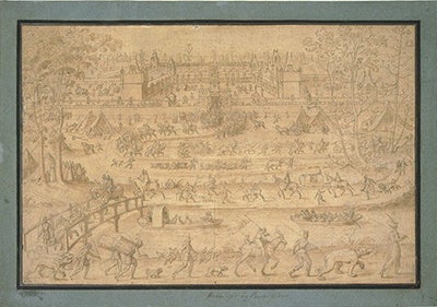
In the early modern period, the kingdom of France consisted of far-flung territories inhabited by culturally and linguistically diverse peoples whose loyalty to the throne was tenuous. Governing such a state required a variety of strategies, one of which was the royal family’s physical presence. Before famously settling at Versailles late in the 17th century, the various groups that composed the crown—the entourages of the king, queen, and the royal children—pursued feverish but largely separate itineraries. Travel was arduous and could be perilous, but the benefits movement offered in terms of security, health, and political strategy outweighed its discomforts. In their journeys, they inhabited buildings that ranged from hunting lodges to urban palaces and nobles’ residences. Together, these edifices participated in an interconnected network of architecture that helped to define the monarchy’s relationship to its kingdom. “The Mobile Monarchy” maps the choreographed displacements of the French royals from the rise of Louis XII to the death of Louis XIV. Using itineraries gleaned from account books, correspondence, and royal acts, the project addresses itinerancy as a central architectural concern and a critical political tool that underpinned dynastic hegemony.
1767: Two Trips to the Northern Frontier of New Spain
Marie Saldaña
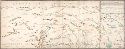
The year 1767 was important in the formation of early Texas, one that saw a shift away from the mission-presidio pattern of occupation, towards the growth of settlements comprised of land-owning civilians. Between June and November 1767, the Marques de Rubí, on orders of King Carlos III, traveled through the province of Texas to inspect the military installations. Unimpressed by what he found, Rubí recommended the complete withdrawal of Spanish presence from east Texas, and the reinforcement of a “realistic” frontier that ran from Mission San Juan Bautista (approx. 35 miles downriver from Eagle Pass), to Matagorda Bay. The summer of 1767 also saw the “General Visit” of the Royal Commissioners, whose purpose was to adjudicate land grants to the settlers in the five Villas del Norte established by José de Escandón in the Lower Rio Grande Valley between 1749-1755 (Laredo, Revilla, Mier, Camargo, and Reynosa). Though part of the province of Nuevo Santander at the time, and not part of Texas until 1845, the ranches established by these settlers north of the Rio Grande not only influenced the vernacular architecture and pattern of land tenure in the region, they also brought with them the ranching culture whose influence is felt in Texas to the present day. This project traces the simultaneous unfolding of these two “visits” - by the Marques de Rubí, and the Royal Commissioners - through their own words, demonstrating how they perceived and shaped distinct Tejano populations. The project is also interested in the engineers and surveyors, instrumental on both expeditions, who were responsible for measuring, documenting, and mapping the land and settlements they encountered.
The Travelog of Antonio de Beatis, 1517-1518
Kyle G. Sweeney
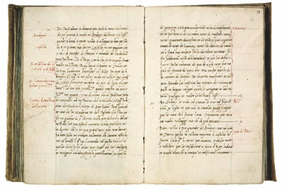
On May 9, 1517, Cardinal Luigi of Aragon set off from Ferrara on a grand tour of Germany, Switzerland, the Low Countries, and France. The journey, which took over eight months to complete, was recorded by Don Antonio de Beatis, his chaplain and scribe who accompanied him on the vast expedition. Although de Beatis’ travel account is known for its descriptive entry concerning his encounter with an aging Leonardo da Vinci, who was in the employ of king Francis I at the time, one wonders how his counterclockwise movement around western Europe influenced his reception and evaluation of architecture and cities outside his homeland. How did he formulate meaningful comparisons and articulate his experience of the built environment from day to day? Which places were significant to him and why? Plotting the sequence of towns and specific monuments as encountered by de Beatis will allow us to create a comparative, critical framework that relates his descriptive accounts of châteaux, monasteries, cathedrals, churches, castles, towns, and cities to his movement across space over time. Perhaps then we can begin to understand why de Beatis dismissed Notre-Dame de Paris as “not very beautiful,” while others, like the cathedral of Nantes, were praised for their “very fine” impressions. Indeed, mapping de Beatis’ range of responses reveals that he had a high degree of visual literacy for a time that featured myriad architectural styles across many cultures.
Moves Like Louis Armstrong, 1901-1922
Laura Richardson

Moves Like Louis Armstrong, 1901-1922, follows the early years of Louis Armstrong’s life, mapping his movement from his roots in New Orleans through his experiences on a Mississippi River steamboat. The combination of location points with audio recordings of Armstrong’s style in a string of specific geospatial and temporal locations allows for a clearer visualization of Armstrong’s contribution to the migration of Dixieland jazz from its origins in New Orleans to the ears of Midwesterners. Scholars disagree about the degree of influence Armstrong’s style had on developing regional and national jazz forms, but there’s no doubt that Satchmo’s American explorations chart an exciting narrative map of the changing landscape of jazz in the early twentieth century.
Elisabeth Narkin | A. W. Mellon Postdoctoral Fellow
Ph.D. Art, Art History and Visual Studies, Duke University
Elisabeth is an architectural historian of early modern France whose research focuses on the intersection of the domestic spaces of châteaux and the social spaces of court relationships. Her current project, Constructing Dynasty: Architecture and the French Royal Family, examines the manner in which the royal family's architecture projects, residential habits, and use of buildings--both independently and within the monarchy's territorial network--advanced a conception of the sixteenth-century monarchy as legitimate, enduring, and in touch with its subjects. With a focus on the royal children as central actors in the crown's long-term socio-political strategies, the project explores domestic architecture from the perspective of its users and argues that their relationship with buildings shaped the built environment as well as French politics. In addition to object-based inquiry and social history, Elisabeth deploys analytical tools like digital mapping and 3D modeling alongside spatial theory to understand spaces that physical changes and non-traditional sources might otherwise obscure.
Marie Saldaña | A. W. Mellon Postdoctoral Fellow
Ph.D. Architecture, UCLA
Marie Saldaña received her PhD in Architecture at UCLA in 2015. She studies the interrelationship of geography and landscape with the built environment. Her current work focuses on the geographic, demographic, and architectural history of Texas and Northeastern Mexico in the Spanish colonial and early Mexican periods.
Laura Richardson | Project Manager Fellow
Ph.D. English, Rice University
Laura studies American and British modernism. Her current spatial project examines Houston in the 1920s, specifically the city’s cultures of bootlegging. With digital mapping technologies, she is creating an interactive map of Houston in the Roaring 20s, pinpointing speakeasies, busted bootlegging enterprises, and Prohibition-related organized crime efforts. Traditionally, accounts of the Roaring 20s focus exclusively on New York City or Chicago. This project defines Houston’s relationship to the decade that put it on the map, plotting the city’s—and with an eye for Texas’—role in “the Mad Decade.” Laura’s book project, Everyone’s a Critic: Eclectic Modernist Hermeneutics, examines the history of modernist criticism. Female critics were left out of literary criticism’s shift from the pens of poet-scholars to a codified system of analysis in American and British universities. Laura’s work is an archival project that recovers alternative methodologies of literary analysis from the early twentieth-century.
Kyle G. Sweeney | Project Manager Fellow
Ph.D. Art and Architectural History, Rice University
Kyle studies the relationship between Gothic architecture and the social, spatial, and ritual topography of towns and cities in late medieval Normandy. His research focuses on how a confluence of new social values, economic prosperity, and urban rituals gave rise to the extravagant displays of technical virtuosity and sophisticated ornament typical of ecclesiastical architecture at the turn of the sixteenth century. Kyle is particularly interested in visualizing the organization of urban space surrounding churches, as well as the public religious celebrations and royal entries that shaped the experience of the city at the end of the Middle Ages.
